

- Home
- Scarrows
- Mariners
- Cumberland
- Miscellaneous
Cockermouth
History
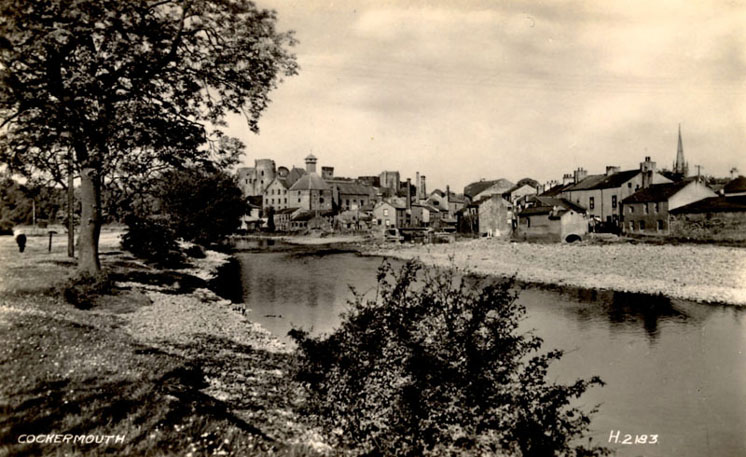
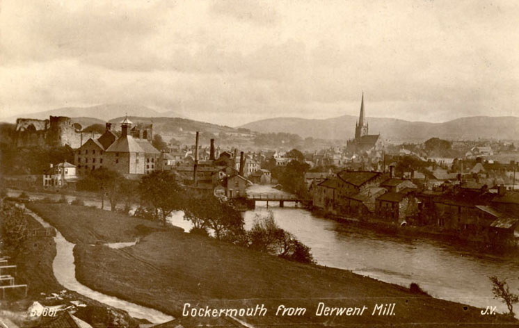
Cockermouth owes it existence to the river system. The nearby Roman camp of Dervenitio, modern Papcastle, was situated at the northern end of a crossing of the river Derwent, which flows from east to west just north of the present town centre. Here was an important road junction in the back-up to Hadrian's Wall. Also originating in the central Lakeland fells, the Cocker flows from the south to enter the Derwent here, hence the name of the town. At this confluence grew the normal and medieval settlements, a natural administrative and trading centre for a number of converging valleys.
Little happened after the Romans left about AD 400 until the Normans arrived, but place names and Anglian remains in nearby churches prove the continued existence of communities in the area. Governing the district first from the former Roman site, the Normans soon moved to the present castle site on the end of a ridge between the rivers at their confluence. The town developed below the castle and for some distance west along the line of the present main street. In 1260 about 180 burage properties were listed, in addition to the mills, workshops, etc of an active and growing community. Excavations in 1980 proved habitation at the western end of Main Street by 1300.
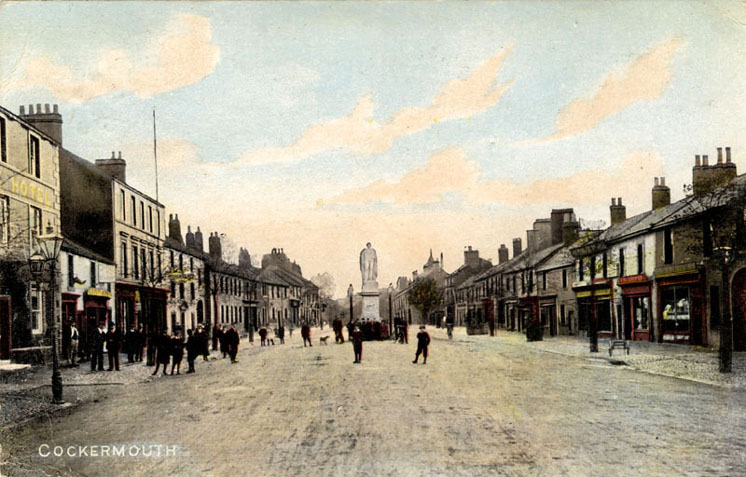
Cockermouth developed as a typical medieval town, having a broad main street of burgesses' houses, each with a burgage plot stretching to the usual 'back lane' - the Derwent bank on the north and Back Lane,(now South Street) on the south. This basic layout of streets and plots still largely remains one reason for the town's inclusion as one of the fifty one 'gem towns' selected in 1965 by the British Council for Archaeology as being worthy of special care in preservation and development, 'so splendid and so precious that ultimate responsibility for them should be a national concern'.
The town grew in importance as shown by the fact that at one time there were six MPs for the former county of Cumberland - two for Carlisle, two for Cockermouth and two for the county as a whole and voting for these last two took place in Cockermouth! In addition to its market town life it was involved in West Cumberland trade. Although geographically cut off from much of the country it was linked to national events through the lord of the manor, the castle owners including the Lucy family (pre 1365); Percy, Earls of Northumberland (1385-1670); Seymour, Duke of Somerset (1670-1750); and Wyndham (since 1750). Many of these were largely absentee landlords as far as Cockermouth was concerned, being involved in state affairs from one of their other, more accessible, seats.
Always a textile area, the town had a fulling mill by 1156, probably earlier. When machinery was invented to speed up spinning and weaving the domestic industry declined and Cockermouth, with its ample water supply, became a mill town. In the mid nineteenth century there were over forty industrial sites - mills (wool, linen, cotton), hat factories, tanneries and smaller concerns making chairs, churns, mangle rollers, nails, farm machinery, etc. Throughout this period of industrial activity, now over, the town remained an important agricultural centre and today farming, tourism, one factory, a brewery and a growing number of small commercial and business concerns provide local employment, supplemented by industry along the West Cumbrian costal belt, in particular Sellafield. Most mill buildings have been demolished, but some remain, converted to other uses.
Description of Parish
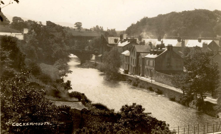
The ancient borough of Cockermouth occupies a beautiful and advantageous situation in the heart of a most picturesque and highly-cultivated country, on the south side of the river Derwent, and at the mouth of the Cocker, whence is derived its name, 8 miles E. of Workington, 7 miles S.E. of Maryport, 14 miles N.E. of Whitehaven, 27 miles S.W. by W. of Carlisle, and about 305 miles N.W. of London. Camden, who visited Cockermouth in 1582, describes it as "a populous, well-trading market town, neatly built, but of a low situation, between two hills, upon one of which is the church, and upon the other, over against it, (which is evidently artificial) a very strong castle, on the gates whereof, are the arms of the Moltons, Umfravills, (Nevills) Lucies, and Percies." Bishop Nicholson, who wrote in 1685, says, "the houses are built of stone, and slated mostly with blue slate; they comprise two streets, one above the river Cocker, in which is the Moot Hall, Market-house, Corn-market, and Shambles." The old Moot Hall and the wooden Shambles, being a great nuisance to the place, were taken down in 1829, and in the same year the present convenient Court-house, or Town-hall, Bank, and News Room, were erected by subscription, at a cost of £1300 raised in shares of £26 each, exclusive of the materials of the old Moot Hall, which were given by the earl of Egremont. They form one handsome range of white freestone buildings, on the west side of Cocker bridge, which was built, in 1828, on the site of the old one, at a cost of £2600, including the expense of removing several houses, "for the purpose of widening the entrance on both sides of the river." It is 160 feet long, and connects the eastern and south-western parts of the town. The Derwent bridge, which has two arches 270 feet in length, forms a continuation of the road from Maryport. Besides being intersected by the Derwent and Cocker rivers, the town is also refreshed by two smaller streams which rise a few miles east, and are a great convenience to the manufacturers of Cockermouth and neighbourhood. A new market-house was erected at the top of Market-street, in 1837, by subscription, towards which the late earl of Egremont gave £200.
Although this town is in a low situation, and at the confluence of two rivers, it is, nevertheless, exceedingly healthy, as is evident from the bills of mortality published a few years since, shewing the number of deaths registered during five years, in 114 districts, containing, in 1841, a population of 6,534,555 souls, by which it appears that the lowest rate of mortality was in Anglesey, Cockermouth, and the Isle of Wight. In 1842, there were interred in Cockermouth church yard, 19 persons whose united ages amounted to 1591 years, being an average of 83 years each; and between the 1st of January, 1846, and the 1st of June, 1847, there were interred 40 individuals whose united ages made 3921 years, being an average of more than 80 years each. From 1636 to 1646, there were 414 baptisms, 272 burials, and 121 marriages; from 1781 to 1791 there were 685 baptisms, 663 burials, and 175 marriages registered, being an increase of 271 baptisms, 386 burials, and 55 marriages, in ten years. In the year 1842, the number registered was 143 births, 128 deaths, and 32 marriages, a considerable increase since 1791. In 1785, the town contained 663 families, numbering 2652 inhabitants, being an average of four persons to each family; in 1801, its population was about 2800; in 1811, 2496; in 1821, 3790; in 1831, 4536; and in 1841, it contained 4940 souls, and 1196 houses.
In Hutchinson's History of Cumberland, published in 1795, it is stated that "The market is held on Monday, weekly; and every fortnight there are shows of cattle on the Wednesdays, in the great street, from the beginning of May until Michaelmas. There are likewise two general fairs held in the market-place, on Whitsun Monday and Martinmas Monday, for hiring servants. Men's wages, on an average, are £10 a year, and women's wages, £4 a year. There is a considerable manufactory carried on in hats, which employ about 100 hands; of coarse woollen cloths and shalloons1, in which about 300 hands are employed; of checks and coarse linens there are about 50 hands; and the leather trade, in various branches, employs about 50 hands. The whole place bears the countenance of opulence."
The corn market, which is still held on Monday, is abundantly supplied with grain and all kinds of provisions; and the cattle markets, held every alternate Monday, are numerously attended. Here is also another large horse and cattle fair, on the 18th of February; and there are now in the town and neighbourhood, four sewing thread manufactories, and flax and tow spinning establishments, at which several hands are employed; the Messrs. J. Harris and Sons alone employ upwards of 200, and their factories were greatly enlarged in 1847. Here are also three cotton check and gingham, and two woollen, manufactories, six tanneries, three currieries, two skinneries, three hat manufactories, and a large brewery and malstery, &c.
The chapelry contains 2147A. 2R. 34P., and the rateable value of its lands and buildings, in May, 1847, was £11,283 12s. 4d. It is about five miles in length from east to west, and two miles in breadth from north to south, being bounded on the north by the Derwent, on the east by the lake of Bassenthwaite. on the south by the parishes of Embleton and Lorton, and on the west by the township of Brigham. The common lands were enclosed pursuant to an Act of Parliament passed in the 53rd of Geo. III. "Beneath the castle," says Hutchinson, "on the margin of the river Derwent, is a plain of considerable extent, in which is a public walk, almost a mile in length; the stream falls over a rough channel; the opposite banks are in tillage; whilst the plain is laid out in meadows bounded by a gentle ascent covered with wood. This walk is beautifully terminated at each end; one by lofty cliffs scattered over with trees, the other by the ruins of the castle impending over the river, which is crossed by a bridge of two arches, forming a communication with the village of Derwent,* seen hanging on the distant declivity." The rivers abound with salmon, trout, brandling2, pike, eels, and other smaller fish.